Japan Highway Toll Calculation! 5 Methods to Check, Calculate Toll Fees, and Payment Options
I often receive inquiries from netizens about Japan’s highway tolls, with the most common question being whether using passes like HEP, KEP, or SEP for their itinerary is cost-effective. To determine if an ETC Pass is worth it, you simply need to calculate the regular toll fees for your planned route and compare them with the pass price. Here, I’ll introduce 5 methods to check Japan’s highway tolls, explain how to estimate toll fees, and also cover Japan’s highway payment methods.
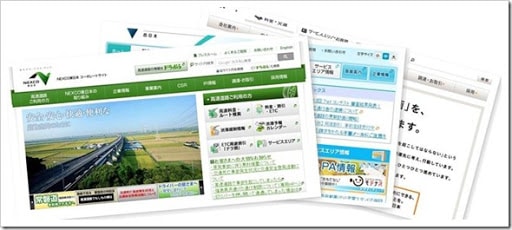
Japan’s highways are primarily operated and managed by three companies: NEXCO East Japan, NEXCO Central Japan, and NEXCO West Japan. NEXCO East Japan manages highways east of Tokyo, including Hokkaido, Tohoku, Kanto, and parts of the Hokuriku region. NEXCO Central Japan covers highways west of Tokyo to Osaka and Kyoto, including the Tokai, Hokuriku, and Chubu regions. NEXCO West Japan is responsible for highways west of Osaka and Kyoto, including Okinawa, Kyushu, Shikoku, Kansai, and the Chugoku region.
5 Methods to Check Japan’s Highway Toll Fees
There are several ways to check Japan’s highway tolls, with the five main methods being:
- Using highway toll tables to check fees between two interchanges (IC);
- Using the toll calculation system on highway company websites to check fees between two ICs;
- Using highway toll apps to check fees between two ICs;
- Using navigation map websites to check tolls for the entire route from departure to destination;
- Estimating approximate tolls by multiplying the travel distance by the average toll per kilometer.
Before checking highway tolls, it’s important to understand Japan’s vehicle classification system. Different vehicle types are charged differently, categorized into the following five classes:
- Light vehicles (cars under 660cc) and two-wheeled vehicles (motorcycles)
- Standard vehicles (cars over 660cc with seating for up to 11 passengers)
- Medium-sized vehicles (cars with 11–29 seats, trucks under 8 tons)
- Large vehicles (buses under 9 meters, trucks between 8–20 tons)
- Extra-large vehicles (buses and trucks exceeding the above standards)
Foreign tourists driving in Japan typically rent standard vehicles, though some may opt for light vehicles for short trips.
Using Highway Toll Tables to Check Fees Between Two Interchanges (IC)
The simplest way to check Japan’s highway tolls is to use toll tables provided by highway companies. These tables display the toll fees between two highway interchanges (ICs).
Here are the toll tables for Japan’s three major highway operators:
- NEXCO East Japan Toll Table – Hokkaido, Tohoku, Kanto, Hokuriku
- NEXCO Central Japan Toll Table – Tokai, Hokuriku, Chubu
- NEXCO West Japan Toll Table – Kansai, Chugoku, Kyushu, Shikoku, Okinawa
Highway toll tables come in different designs. The simplest is a triangle format, where IC names are listed along the hypotenuse, and the intersection of two IC names shows the toll between them. For example, the red box in the image below indicates the toll from Sapporo IC to Asahikawa-Takasu IC.
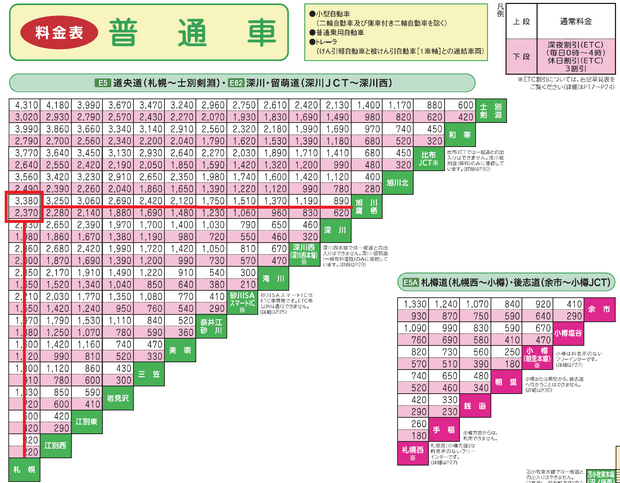
The toll table usually displays two numbers: the higher one is the standard toll, and the lower one is the discounted ETC toll. Currently, ETC discounts are mainly available during late-night hours and holidays.
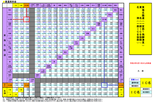
Some toll tables use a rectangular design, providing more details. In these tables, IC names are listed on the X-axis, Y-axis, and a diagonal line in the middle. The toll is checked the same way, but additional information like distance (in kilometers) is provided. For example, the red box in the image below shows the distance, standard toll, and general discounted toll from Nagoya IC to Shirakawa-go IC, while the blue box shows late-night and holiday discounts.
Using Highway Company Websites to Check Toll Fees Between Two ICs
The official websites of NEXCO East Japan, NEXCO Central Japan, and NEXCO West Japan all feature toll calculation systems. Any of these systems can check tolls nationwide, so you only need to use one.
Here are the toll calculation system links for the three companies:
- NEXCO East Japan Toll Calculator – https://www.driveplaza.com/dp/SearchTop
- NEXCO Central Japan Toll Calculator – https://dc.c-nexco.co.jp/dc/DriveCompass.html
- NEXCO West Japan Toll Calculator – https://search.w-nexco.co.jp/
In terms of functionality and ease of use, I prefer NEXCO Central Japan’s toll calculator. The steps below use it as an example, but the other two systems work similarly.
NEXCO Central Japan’s toll calculator offers three methods: directly entering IC names, selecting ICs on a map, and choosing ICs from a highway menu. I find the map method the most intuitive, so I’ll focus on that.
Here’s how to check highway tolls:
Note: The following example calculates the toll from Nagoya Station to Shirakawa-go.
1. Before checking tolls, identify the start and end points of your route. I usually use Google Maps to locate nearby areas and landmarks. Note that Google Maps may not always label highway ICs, and names might differ from the toll calculator.
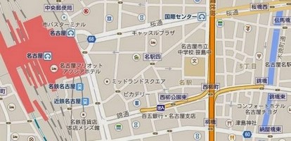
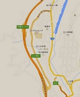
2. Once you’ve identified the start and end points, go to NEXCO Central Japan’s toll calculator and select the region of your starting point on the map, such as “Tokai” or “Nagoya Expressway.” For this example, click “Nagoya Expressway.”

3. On the map, you’ll see ICs near Nagoya Station, such as “Meieki” and “Nishibashi.” Note that not all ICs allow both entry and exit—some are entry-only or exit-only.
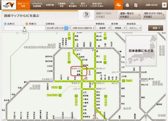
Hovering over an IC displays pink or light blue arrows. Pink arrows indicate exit-only, light blue arrows indicate entry-only, and both arrows mean the IC allows both entry and exit.


For this example, only “Meieki” allows entry, so select it as the starting IC (click “Meieki” and then “Set as Departure IC”).
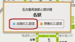
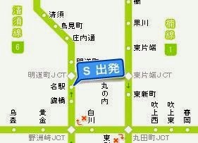
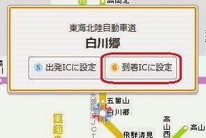
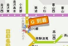
4. After setting the starting IC, move the map to Shirakawa-go and set it as the destination IC (same process as above).
5. Click “Search” to view the toll fees. (Note: If you only want to check the standard toll and distance, you can ignore the date and time settings. However, to see ETC discounts for specific times, adjust the date and time.)

Note: Vehicle Classification in Highway Tolls
Japan’s highway tolls vary by vehicle type, categorized as “Light/Two-Wheeled,” “Standard,” “Medium,” “Large,” and “Extra-Large.” “Light/Two-Wheeled” includes motorcycles and light cars under 660cc, while “Standard” refers to passenger vehicles with up to 11 seats. Most rental cars for tourists fall under the “Standard” category, so no changes are needed when checking tolls.
6. If multiple routes are available between the start and end points, the system will display the distance, travel time, standard toll, and ETC discount toll for each. (Note: ETC discounts now include “ETC” and “ETC 2.0,” but rental cars typically use the older ETC system, and the discounts are usually the same.)
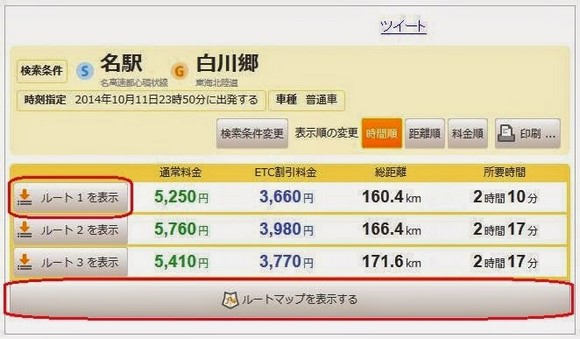
Click “Show Route Map” to view the map for each route.
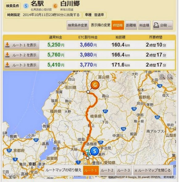
Click “Show Route X” to view the roads, distances, and tolls for each segment of the route.
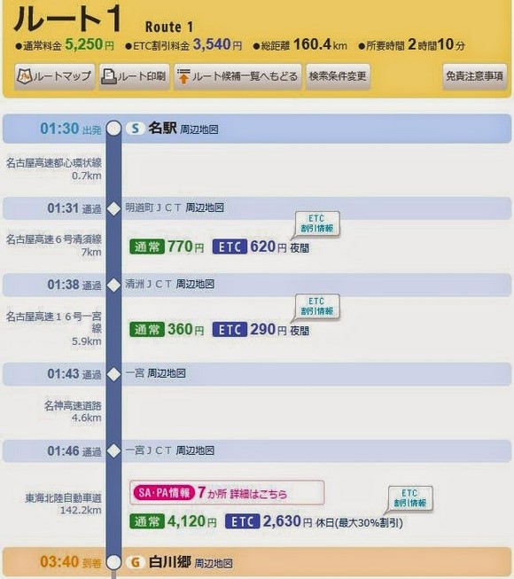
If you’re comparing whether an ETC Pass is cost-effective, sum the standard tolls for your planned routes and compare them with the pass price. Note that some highways may not be covered by ETC Passes.
Using Highway Toll Apps to Check Fees Between Two ICs
While NEXCO East Japan and NEXCO Central Japan offer toll calculation apps, NEXCO Central Japan’s app isn’t very user-friendly, and NEXCO East Japan’s app is only available for Japanese accounts and isn’t great either.
However, third-party apps like “Highway Toll Calculator – Tolls, Traffic, Parking” (iOS only) or “Highway Navi (Traffic, Toll Search)” (Android) are more convenient and ad-free.
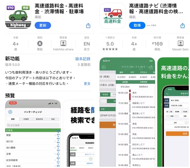
To check tolls in the “Highway Toll Calculator” app, simply set the departure and arrival ICs on the main page (Route Search) and click “Search.”
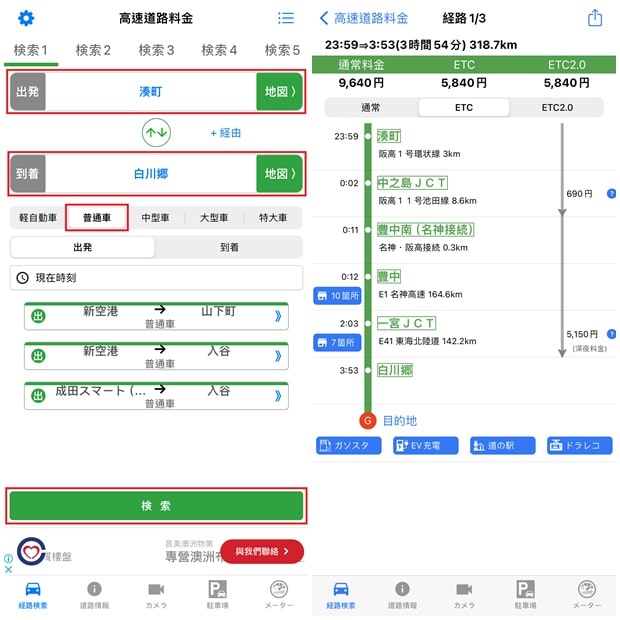
The app offers three ways to set ICs: typing the name, selecting from a list, or choosing from a map. For foreigners, the map method is easiest. (Tip: Click “Map” in the Route Search page to select ICs directly.)
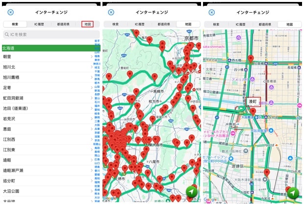
Using Navigation Maps to Check Tolls for the Entire Route
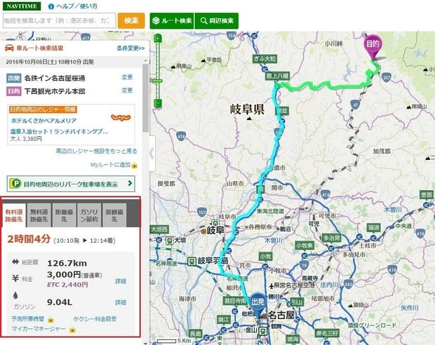
If you’re unsure about highway ICs, use Japan’s NAVITIME website or app. Enter your start and end points, and if the route includes highways, the toll will be displayed.
Estimating Tolls by Distance
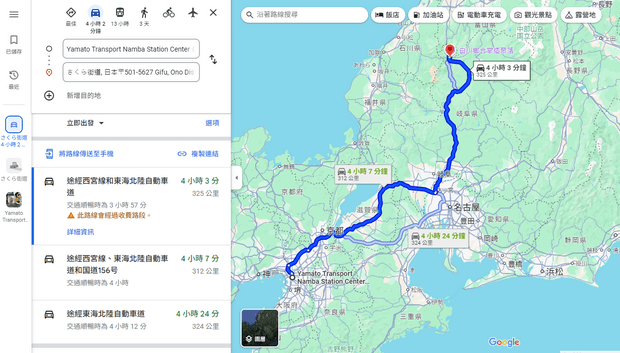
For a quick estimate, multiply your travel distance by the average toll per kilometer (about ¥28–33, including tax). Urban highways (e.g., Tokyo, Osaka) cost around ¥33/km, while rural highways cost around ¥28/km. For example, a 320 km trip from Osaka Namba to Shirakawa-go would cost roughly ¥9,600 (¥30/km), close to the actual toll of ¥9,640.
Japan Highway Payment Methods: Cash vs. ETC
Japan’s highways accept cash or ETC. With cash, you take a ticket at entry and pay at exit. However, cash payments have drawbacks:
- Time-consuming – Stopping for tickets and payments adds delay, especially during peak times.
- Limited access – Some ICs are ETC-only, forcing detours.
- No discounts – ETC offers discounts on weekends, holidays, and late nights.
Most rental companies offer ETC cards for ¥330, making them a cost-effective choice.
Related posts:
- Kyushu Expressway Pass (KEP): Pricing, Coverage, and Where to Buy
- Japan Toyota Rent a Car Guide: Official Website Rental Process and Discounts!
- Visit Japan Web (VJW) Guide for Filling Out Japan Arrival QR Code
- Japan Universal Studios Tickets, Fast Pass, VIP Tour: Official Website Purchase Guide
- Universal Studios Japan App Tutorial! How to Use the USJ App to Obtain Timed Entry Tickets
- Osaka Mint Bureau Sakura Avenue Reservation Guide
- Osaka Light Festival: Event Details, Schedule, Venues and Transportation
- Tateyama Kurobe Opening Dates, Transportation, Attractions, Luggage Delivery, and Travel Guide
- Guide to Purchasing Tateyama Kurobe Tickets, Train Tickets, JR Passes, and Booking Ride Times
- Tateyama Kurobe Snow Otani: Opening Hours, Snow Wall Height, and Travel Guide
- Tateyama Kurobe Travel Guide: One-Day Itinerary and Recommended Routes (JR and Self-Driving)
- Alpine-Takayama-Matsumoto Area Tourist Pass: Purchase, Exchange, Usage, and Riding Guide
- Japan Kyushu Kawachi Fujien: Wisteria Blooming Season, How to Purchase Tickets, and Transportation Guide
- Japan Toyota Rent a Car Guide: Official Website Rental Process and Discounts!
- Kaiten-Sushi Nemuro Hanamaru: Locations, Crowds, Reservations and Queue-Skipping Tips for Tokyo and Sapporo Branches
- Japan Accommodation Tax: Which Cities Levy It? Who Needs to Pay? How to Pay?
- Japan Rakuten Travel Promo Codes, Latest Discounts, and Booking Tutorial
- How to get and use the 10% Agoda Discount Code


